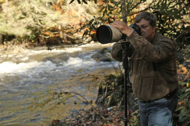
 The ultra light two seater plane we flew around Brandburg Massif in Namibia
Since I wrote the following narrative, I was told that Nico, the Son of The White Lady bed and breakfast, passed away this past summer in an automobile accident. Nico was a wonderful person that was full of life and love of flying. His enthusiasm was captivating. Although I only met him twice, I'll remember his friendship forever. The flight we took around Brandburg Mountain is one of my favorite life experiences and as I mention in the story, I'll remember it for the rest of my life.
I previously posted the Steve Minkin Memorial Water Well story. This described how and why we constructed the well for the miners and area wildlife. The photos in that blog entry were taken last year after the well was constructed and in use.
I previously posted the Steve Minkin Memorial Water Well story. This described how and why we constructed the well for the miners and area wildlife. The photos in that blog entry were taken last year after the well was constructed and in use.
This entry is about the trip where we actually found the location for the well and includes some amazing photos.
Doug picked me up in Windhouk, Namibia on January 19th, 2008 and we went to the Ministry of Water Affairs. We got verbal permission to locate and put in a well. They said the official paperwork would follow and may take some time. As an interesting note, we actually got the official paperwork a few weeks ago on December 12th, 2009; almost 2 years after our request.
The nearest town to the mining camp is Uis, Namibia. (look it up on Google Earth) Uis is our favorite place to visit in Namibia because the people are so friendly, the accomendations are very nice and it is centrally located for day excursions to collect minerals. I think Doug would like to buy a case of cigars, home in Uis and retire there forever. Anyway... We stay at The White Lady bed and breakfast where they have a nice pool, outdoor dining pavilion and nice comfortable rooms. The buildings have thatched roofs which are exposed inside - wonderful ambience.


The Son of the owner, Nico was an avid sports pilot and took people up for rides in his ultra light plane. I talked him into flying me over the mining camp and Brandburg Massif (mountain). This was an adventure of a lifetime. We took off early in the morning and flew above Brandburg. He showed me the highest point in South Africa, where a plane had crashed on the mountain and other interesting sights of the area. The most important part of the 2 hour trip was flying over the mining camp and especially over the site for the water well. You can actually see the containment pond for the well in the photos.
I could go on for some time about the flight, but I think the photos speak for themselves. You can actually see what I saw by looking at this area in Google Earth. It is amazing how similar the photos are to Google Earth.
(Click for full view - Back to return to blog)
 Brandburg Mountain at dawn as we take off for a 2 hour flight
(Click for full view - Back to return to blog)

The light blue spec in the middle of this photo is a Piper Cub airplane that successfully landed on Brandburg Mounatin. Unfortunately they died on impact while trying to take off. There are few people that have seen this wreckage.
(Click for full view - Back to return to blog)
 Flight regulations are the same in an ultra light as they are for any other aircraft. We had to stay at least 500' above the highest point on the mountain. 9300' is amazingly high in an open air aircraft.
(Click for full view - Back to return to blog)
 The pile of stones in the middle of this photo is the highest point in Southern Africa. In the background, notice what appears to be the Atlantic Ocean. What you're seeing is actually a fog layer that comes in from the cool waters of the coast 80 miles to the West.
(Click for full view - Back to return to blog)
 Another Massif. Although you cannot see it, Steve's Water Well site is just above the bar on the left side of this photo.
(Click for full view - Back to return to blog)

This is a dramatic view of the mining village Steve became so enamored with. Notice the white specs in the middle of the photo. They are the shantis the miners live in. I brought 2 10x20' plastic tarps which provided valuable cover for their shacks. As you can see there is no water, vegetation or food available - anywhere. Because of the water well we constructed in Steve's memory, they do have drinkable water now.
If you look closely in the center of the photo, you can see the pothole mines on the sides of the slopes.
(Click for full view - Back to return to blog)
 Notice the small white circle in the lower middle of the photo. This is the concrete containment pond which now has a water well and windmill. This provides water for the local wildlife and people of the mining village.
 (Click for full view - Back to return to blog)

Here is a close up areal view of the concrete containment pond. The concrete pedestal above and to the left of the pond is the old abandoned well. I can't wait to see the finished well on my visit next month.
No comments:
Post a Comment